
Trajan's Bridge at Drobeta: what the sources say and what remains
Built in 103–105 by Apollodorus of Damascus for the second Dacian war, the bridge at Drobeta was described by Cassius Dio and Procopius. Today the end piers can still be seen, on the Romanian and the Serbian banks.
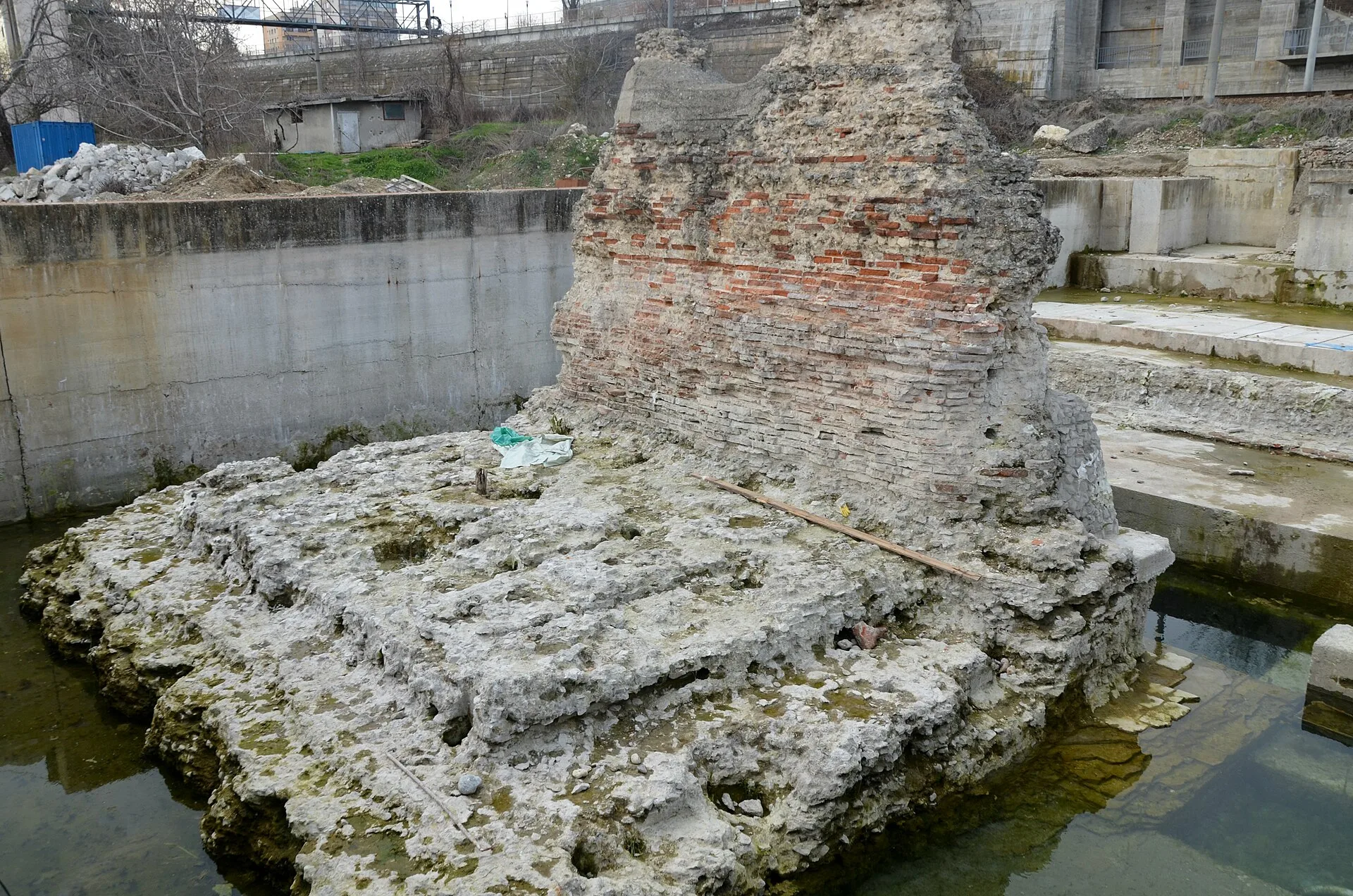
A bridge for the second Dacian war
After the peace made with Decebalus in 102, the Romans began a stone and timber bridge across the Danube at Drobeta. Work lasted from the spring of 103 to the spring of 105, and the bridge served Trajan's troops in the second Dacian war. Its architect was Apollodorus of Damascus, to whom Trajan's Column is also attributed.
The bricks in the piers show who built it. Stamps of the Seventh Legion Claudia have been found in them, in 1896, in 1984 and during the 2020–2021 restoration. Detachments of the legions V Macedonica and XIII Gemina and of the cohorts I Cretum, II Hispanorum and III Brittonum are also believed to have taken part.
What the ancient authors wrote
The Roman historian Cassius Dio (Book LXVIII, chapter 13) says he cannot admire Trajan enough for this bridge. According to him, it had twenty piers of squared stone, 150 feet high above the foundations and 60 feet wide, standing 170 feet apart and joined by arches. Dio stresses how hard the work was: the river was deep, full of eddies and with a muddy bottom, and its course could not be diverted. Trajan built it, he writes, because he feared that when the Danube froze the Romans on the far bank might be attacked, and the bridge made it quick to reach them.
Procopius of Caesarea, writing in the reign of Justinian, discusses the bridge in his "Buildings" (IV.6). He calls Apollodorus of Damascus "the chief architect of the entire work" and says he will not describe the construction himself but leaves that to Apollodorus (the architect's own account has not survived). He also writes that Trajan built a fort on each bank, and that the one on the right bank was named Pontes, from the Latin word for bridge.
Dio's figures are his own, not modern measurements. The estimate used today for the bridge's total length is about 1,135 metres.
How the bridge disappeared
The ancient sources disagree. Dio writes that Hadrian, Trajan's successor, removed the superstructure, fearing that barbarians might overpower the guard and cross into Moesia; in Dio's time only the piers were still standing. Procopius says only that the bridge was destroyed by the Danube and by age, and that the ruined piers blocked navigation, so the river was forced to take a new course around the site.
What survives today
On the Romanian bank, next to the Iron Gates Region Museum, the end pier (the portal pier) and remains of the neighbouring piers survive. In 1984, before the Iron Gates II dam raised the Danube by about 5 metres, the ruins were enclosed in concrete basins, in rushed works carried out without archaeological research. The latest restoration took place in 2020–2021. On the Serbian bank, at Kostol near Kladovo, the ruins of the pier at the other end can be seen.
Next to the bridge, in the museum grounds, lie the ruins of the Roman fort of Drobeta, dated to the 2nd–6th centuries, together with baths and an amphitheatre.
On the Serbian bank, about 30 km from Kladovo, is the Tabula Traiana, an inscription carved into the rock. It does not refer to the bridge but to the Roman road cut into the cliffs along the river, and it is dated to the year 100. When the waters of the Iron Gates dam flooded the road, the plaque was cut out and moved higher up. It can be seen only from the Danube.
Where you can see it
The ruins of the pier on the Romanian bank stand in the archaeological park of Drobeta-Turnu Severin, next to the museum and the fort ruins. The Iron Gates Region Museum (2 Independenței Street) has a model of the bridge, made in the 1970s from the reliefs on Trajan's Column and Cassius Dio's description, and its archaeology collection holds stamped bricks from the bridge piers.
Places in this story
- Ruins of Trajan's Bridge (Romanian bank pier)Drobeta-Turnu Severin, Mehedinți CountyPila portal și resturile pilelor alăturate, în cuvele de beton din 1984, restaurate în 2020–2021; în parcul arheologic de lângă muzeu.
- Iron Gates Region MuseumDrobeta-Turnu Severin, Mehedinți CountyAre macheta podului (realizată în anii ’70, după Columna lui Traian și Cassius Dio) și cărămizi ștampilate din pilele podului în colecția de arheologie.
Sources
- Cassius Dio, Istoria romană LXVIII.13–14 (trad. E. Cary, Loeb, LacusCurtius): pilele, dimensiunile, motivul construcției, Hadrian
- Procopius, Despre edificiile lui Justinian IV.6 (trad. A. Stewart, Palestine Pilgrims' Text Society, vol. 2, 1896, Internet Archive): Apolodor din Damasc, forturile, Pontes, distrugerea
- V. Bunoiu, F. Matei-Popescu, G. E. Văcuță, „Noi cărămizi ștampilate ale legiunii VII Claudia pia fidelis din Podul lui Traian de la Drobeta”, Cercetări Arheologice 30.1, 2023, pp. 109–144
- Euronews România (27.10.2025): Muzeul Regiunii Porților de Fier, macheta Podului lui Traian, piciorul podului
- EAGLE (Europeana network of Ancient Greek and Latin Epigraphy): Tabula Traiana (anul 100, drumul) și Podul lui Traian (1.135 m, Pontes–Drobeta)
- Asociația Pro-Mehedinți: Tabula Traiana (mutată mai sus după barajul Porțile de Fier, vizibilă doar de pe Dunăre)
- cIMeC: Muzeul Regiunii Porților de Fier (pagina arhivată): monumentele romane din Drobeta, istoricul muzeului
- Lista monumentelor istorice din județul Mehedinți (Wikipedia, după LMI): MH-I-s-A-10047, .03 castrul, .04 podul, MH-II-m-B-10187 muzeul
- Podul lui Traian (Wikipedia ro)
- Trajan's Bridge (Wikipedia en)
- OpenStreetMap: Piciorul Podului lui Traian (node 1419098099)